
SkylarkTM Precise Positioning Service
Cloud-based GNSS corrections with proprietary atmospheric modeling to enhance performance
Skylark Precise Positioning Service is a cloud-based corrections service that improves GNSS accuracy from several meters to centimeter level. It’s uniquely architected for reliable, affordable
accuracy at mass-market scale. Skylark powers more than 10 million vehicles and devices deployed by leading automotive OEMs, Tier 1 suppliers, robotics companies, and IoT system integrators.
No credit card required
Key Benefits
- Accurate: Proprietary atmospheric model adapts in real-time to outperform other correction systems
- Reliable: Carrier-operated network of best-in-class ground reference stations and enterprise-grade SLAs
- Scalable: AWS-based cloud architecture delivers unparalleled scalability and supports millions of devices simultaneously
- Affordable: Backed by the industry’s largest ecosystem to simplify integration and maximize purchasing power
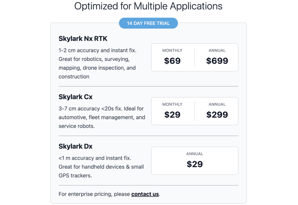
Offered in Three Variants to Support Any Application
- Skylark Nx RTK
- VRS-based Network RTK with advanced atmospheric modeling
- 1-2 cm accuracy and instant fix
- 2x better coverage than single baseline solutions
- Great for robotics, surveying, mapping, drone inspection, and construction
- View interactive coverage map
- Skylark Cx
- PPP-RTK corrections offering uniform performance continent-wide
- 3-7 cm accuracy <20s fix
- Consistent accuracy continent-wide
- Ideal for automotive, fleet management, and service robots
- Skylark Dx
- DGNSS corrections offering uniform performance continent-wide
- <1 m accuracy and instant fix
- Low data and power consumption
- Great for handheld devices & small GPS trackers
Switch between variants at any time during your trial.
The Skylark Difference: Our Proprietary Atmospheric Model
Traditional network RTK services join together many local RTK base stations into a single managed network, connecting your device to the closest base station. At the end of the day, it’s still a single baseline solution. To cover a whole country with this approach, you need a “brute force” network of thousands of stations that is incredibly expensive to maintain.
Swift’s atmospheric model changes the game. Instead of treating every base station as an island, it synthesizes data from an entire network to estimate ionospheric and tropospheric errors over an entire coverage area. With atmospheric modeling, you can achieve the same accuracy and coverage of other network RTK services with fewer base stations.
Our Model Solves Common Industry Challenges
- The 25 km Limit: Corrections from a single base station lose relevance beyond a short baseline. Modeling extends that reach significantly, maintaining precision across distances as high as 70 km.
- The “Jump” Problem: If you’ve ever seen a device’s location “jump” when switching between base stations, you’ve seen a discontinuity error. Modeling enables smooth transitions as devices move between coverage areas, eliminating these erratic shifts.
- Redundancy: With traditional RTK, if a station goes down, corrections are unavailable. In a modeling framework, there is no single point of failure. If one station goes offline, the model automatically adapts using surrounding data to fill the gap.
- Price-Sensitivity: Providers who maintain a massive network of base stations generally pass those costs on to customers. Modeling enables maximum RTK performance with a sparser network of stations, allowing for a more affordable service.